
Emma’s guidebook
Sightseeing
150-acre park containing predominantly mature trees with some open meadowland, and located in Pontypool in south Wales. The park was formerly the grounds of Pontypool House and was laid out in the closing years of the 17th century for Major John Hanbury, the local ironmaster, who is closely associated with Japanware. The grounds were purchased by the local authority in 1920
12 personas del lugar lo recomiendan
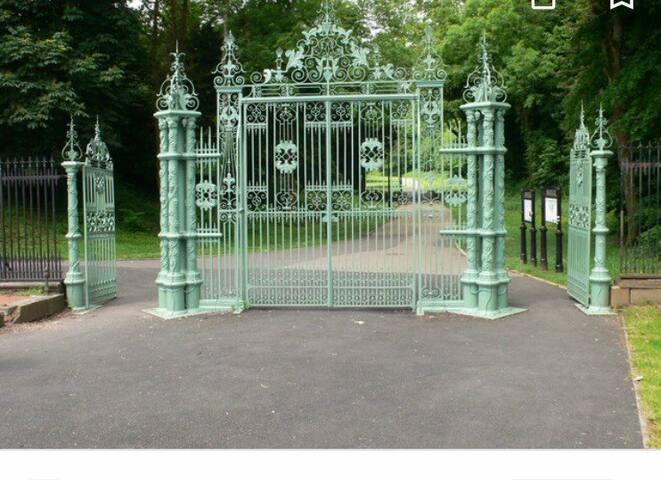
Parque de Pontypool
150-acre park containing predominantly mature trees with some open meadowland, and located in Pontypool in south Wales. The park was formerly the grounds of Pontypool House and was laid out in the closing years of the 17th century for Major John Hanbury, the local ironmaster, who is closely associated with Japanware. The grounds were purchased by the local authority in 1920
Grade II* listed late-18th-century stone built, cylindrical, slate roofed shell grotto decorated with shells and animal bones on the interior. It stands on a prominent ridge 700 ft above sea level, within the boundary of Pontypool Park, Torfaen in south Wales. It is considered to be the best surviving grotto in Wales. It is an important local landmark commanding views south towards the Severn Estuary. A little further along the same ridge can be found the Folly Tower.
Shell Grotto Pontypool Park
Grade II* listed late-18th-century stone built, cylindrical, slate roofed shell grotto decorated with shells and animal bones on the interior. It stands on a prominent ridge 700 ft above sea level, within the boundary of Pontypool Park, Torfaen in south Wales. It is considered to be the best surviving grotto in Wales. It is an important local landmark commanding views south towards the Severn Estuary. A little further along the same ridge can be found the Folly Tower.
The Folly Tower - - is a folly located within the grounds of a working farm, close to Pontypool Park, Torfaen, South Wales. It is a prominent local landmark above the A4042 Pontypool to Abergavenny road and overlooks Pontypool to the west and rural Monmouthshire to the east. The Folly is octagonal in shape and roughly 40 ft high and is approximately 1,000 ft above sea level on the eastern hill range of the Eastern Valley of Monmouthshire, just south of Mynydd Garn-Wen. Less than a mile from the folly is the Shell Grotto.
6 personas del lugar lo recomiendan
Folly Tower
The Folly Tower - - is a folly located within the grounds of a working farm, close to Pontypool Park, Torfaen, South Wales. It is a prominent local landmark above the A4042 Pontypool to Abergavenny road and overlooks Pontypool to the west and rural Monmouthshire to the east. The Folly is octagonal in shape and roughly 40 ft high and is approximately 1,000 ft above sea level on the eastern hill range of the Eastern Valley of Monmouthshire, just south of Mynydd Garn-Wen. Less than a mile from the folly is the Shell Grotto.
View point, Walk/cycle Route. The Garn Lakes is home to a diversity of birds and wildlife. There is also an amenity lake, where activities such as fishing can be enjoyed.
8 personas del lugar lo recomiendan
Garn Lakes
View point, Walk/cycle Route. The Garn Lakes is home to a diversity of birds and wildlife. There is also an amenity lake, where activities such as fishing can be enjoyed.
museum
Pontypool Museum – is an accredited museum located in Pontypool, Torfaen, and South Wales. It is managed by the Torfaen Museum Trust. The museum is situated within the Georgian stable block that once formed part of residence of the Hanbury family – local ironmasters during the 18th and 19th centuries.
Amgueddfa Torfaen Museum
Park RoadPontypool Museum – is an accredited museum located in Pontypool, Torfaen, and South Wales. It is managed by the Torfaen Museum Trust. The museum is situated within the Georgian stable block that once formed part of residence of the Hanbury family – local ironmasters during the 18th and 19th centuries.
an industrial heritage museum in Blaenavon, Torfaen, Wales. A working coal mine from 1880 to 1980, it was opened to the public in 1983 under the auspices of the National Museum of Wales. The site is dedicated to operational preservation of the Welsh heritage of coal mining, which took place during the Industrial revolution. Located adjacent to the preserved Pontypool and Blaenavon Railway, Big Pit is part of the Blaenavon Industrial Landscape and World Heritage Site.
174 personas del lugar lo recomiendan
Museo Nacional de la Mina de Carbón Big Pit
an industrial heritage museum in Blaenavon, Torfaen, Wales. A working coal mine from 1880 to 1980, it was opened to the public in 1983 under the auspices of the National Museum of Wales. The site is dedicated to operational preservation of the Welsh heritage of coal mining, which took place during the Industrial revolution. Located adjacent to the preserved Pontypool and Blaenavon Railway, Big Pit is part of the Blaenavon Industrial Landscape and World Heritage Site.
railway
Passing the picturesque Garn Lakes, Blaenavon’s Heritage Railway travels through the imposing Blaenavon Industrial Landscape, at the highest altitude of any standard gauge preserved railway in England and Wales. www.pontypool-and-blaenavon.co.uk
13 personas del lugar lo recomiendan
Pontypool and Blaenavon Railway
Passing the picturesque Garn Lakes, Blaenavon’s Heritage Railway travels through the imposing Blaenavon Industrial Landscape, at the highest altitude of any standard gauge preserved railway in England and Wales. www.pontypool-and-blaenavon.co.uk
canal
The Monmouthshire and Brecon Canal is a small network of canals in South Wales. For most of its currently passable 35-mile length it runs through the Brecon Beacons National Park. Walkers and cyclists can enjoy the whole route along canal towpaths, cyclists can also follow the National Cycle Network routes 4, 47 and 49 from Newport to Pontypool.
http://www.gps-routes.co.uk/routes/home.nsf/uk/cycling-in-wales
Monmouthshire & Brecon Canal (Pontymoile Basin)
Fountain RoadThe Monmouthshire and Brecon Canal is a small network of canals in South Wales. For most of its currently passable 35-mile length it runs through the Brecon Beacons National Park. Walkers and cyclists can enjoy the whole route along canal towpaths, cyclists can also follow the National Cycle Network routes 4, 47 and 49 from Newport to Pontypool.
http://www.gps-routes.co.uk/routes/home.nsf/uk/cycling-in-wales
Rods at the ready! Goytre Angling Club covers the Monmouthshire & Brecon Canal between bridges 73 and 77. Fishing is permitted from January 1st until December 31st. Day tickets are available to purchase at Goytre Wharf reception, as well as full season passes. (NP7 9EW) https://www.goytrewharf.com/
Season Prices Day Pass Prices
12 Month Membership: £25 Full Day: £2.50
https://fishingguidewales.co.uk/torfaen/
25 personas del lugar lo recomiendan
Puerto de Goytre
Old Abergavenny RoadRods at the ready! Goytre Angling Club covers the Monmouthshire & Brecon Canal between bridges 73 and 77. Fishing is permitted from January 1st until December 31st. Day tickets are available to purchase at Goytre Wharf reception, as well as full season passes. (NP7 9EW) https://www.goytrewharf.com/
Season Prices Day Pass Prices
12 Month Membership: £25 Full Day: £2.50
https://fishingguidewales.co.uk/torfaen/
Food scene
Pontymoile Basin is a mooring point and canal junction on the Monmouthshire Brecon Canal, home to a small canal barge café. “The Boat yard tea room”.
Pontymoile Basin
Pontymoile Basin is a mooring point and canal junction on the Monmouthshire Brecon Canal, home to a small canal barge café. “The Boat yard tea room”.
Horseshoe Fish Bar: 1 Hill St, Pontnewynydd, Pontypool NP4 6NL they also deliver!
Pages Fish and Chip shop: 126 Greenhill Road, Pontypool NP4 5BQ
Horseshoe Fish Bar
1 Hill Street
Horseshoe Fish Bar: 1 Hill St, Pontnewynydd, Pontypool NP4 6NL they also deliver!
Pages Fish and Chip shop: 126 Greenhill Road, Pontypool NP4 5BQ
Harvester Pontypool: Ty Felin Fawr, A472, Pontypool NP4 0RH
Open Hearth pub: Wern Rd, Sebastopol NP4 5DR
Little Crown Inn Wainfelin: Elled Rd, Wainfelin, Pontypool NP4 6DR
Bridgend Inn: Heol Handbury, Pontnewynydd, Pontypool NP4 6QB
Harvester Pontypool
A472Harvester Pontypool: Ty Felin Fawr, A472, Pontypool NP4 0RH
Open Hearth pub: Wern Rd, Sebastopol NP4 5DR
Little Crown Inn Wainfelin: Elled Rd, Wainfelin, Pontypool NP4 6DR
Bridgend Inn: Heol Handbury, Pontnewynydd, Pontypool NP4 6QB
Enjoy a superb meal at the horse show inn and take in the breathtaking views
The Horseshoe Inn & Country Kitchen
Old Abergavenny RoadEnjoy a superb meal at the horse show inn and take in the breathtaking views
water sports
Llandegfedd Reservoir is a large 174 hectare water supply reservoir and is eight miles north of Newport in south Wales. The reservoir is very close to Pontypool, Cwmbran and Usk, with the boundary between Monmouthshire and Torfaen running through it along the former Sôr Brook. Reservoir with boating, fishing, visitor centre with café and water sports centre. http://www.llandegfedd.co.uk/
24 personas del lugar lo recomiendan
Llandegfedd Reservoir
Llandegfedd Reservoir is a large 174 hectare water supply reservoir and is eight miles north of Newport in south Wales. The reservoir is very close to Pontypool, Cwmbran and Usk, with the boundary between Monmouthshire and Torfaen running through it along the former Sôr Brook. Reservoir with boating, fishing, visitor centre with café and water sports centre. http://www.llandegfedd.co.uk/
walking/ hiking
The Afon Lwyd is a 13-mile long river in south-east Wales which flows from its source north of Blaenavon, through Abersychan, Pontnewynydd, Pontypool, Llanfrechfa and Cwmbran before flowing into the River Usk at Caerleon, which subsequently flows into the Bristol Channel in Newport. The river was severely affected by pollution from industry, mine discharge, and fly tipping, but during the 1980s efforts were made to improve the water quality of river and improve fish stocks. To aid this, the Environment Agency Wales built a fish leap at Pontymoile in 2010 enabling fish to ascend past the weir there. By late 2011 it was claimed that the river was in its cleanest state since medieval times. Historically the river has also been known as the Torfaen – meaning 'breaker of stones' – which gives some indication of the force of the river during surges.
Afon Lwyd
The Afon Lwyd is a 13-mile long river in south-east Wales which flows from its source north of Blaenavon, through Abersychan, Pontnewynydd, Pontypool, Llanfrechfa and Cwmbran before flowing into the River Usk at Caerleon, which subsequently flows into the Bristol Channel in Newport. The river was severely affected by pollution from industry, mine discharge, and fly tipping, but during the 1980s efforts were made to improve the water quality of river and improve fish stocks. To aid this, the Environment Agency Wales built a fish leap at Pontymoile in 2010 enabling fish to ascend past the weir there. By late 2011 it was claimed that the river was in its cleanest state since medieval times. Historically the river has also been known as the Torfaen – meaning 'breaker of stones' – which gives some indication of the force of the river during surges.
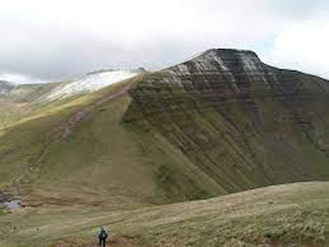
Mynydd Twyn-glas is a sprawling 472-metre-high mountain extending into Caerphilly and Torfaen county boroughs in South Wales. It lies southwest of Pontypool, west of Cwmbran and east of Newbridge and taking the form of a rolling plateau the margins of which are defined by steep slopes, many of which are cloaked with conifer plantations. A broad shoulder extending south from the summit is known as Mynydd Maen whilst to the north is Mynydd Llwyd. The thickly afforested northern slopes of the hill drop down steeply into Cwm y
Mynydd Twyn-glas
Mynydd Twyn-glas is a sprawling 472-metre-high mountain extending into Caerphilly and Torfaen county boroughs in South Wales. It lies southwest of Pontypool, west of Cwmbran and east of Newbridge and taking the form of a rolling plateau the margins of which are defined by steep slopes, many of which are cloaked with conifer plantations. A broad shoulder extending south from the summit is known as Mynydd Maen whilst to the north is Mynydd Llwyd. The thickly afforested northern slopes of the hill drop down steeply into Cwm y
Twmbarlwm, also known as Twm Barlwm, Twyn Barlwm or locally known as "the Twmp", the Nipple or the Pimple because of the mound that lies at its summit, is a hill situated 2 km to the northeast of Risca in South Wales. It is often mistakenly referred to as a mountain but is actually a hill due to being under 600 m. It is 419 m high and is a well-known landmark throughout the region. It commands extensive views across what is now the M4 corridor, over Newport and Cwmbran - with part of it coming into Cwmbran - and out over the Bristol Channel.
7 personas del lugar lo recomiendan
Twmbarlwm
Twmbarlwm, also known as Twm Barlwm, Twyn Barlwm or locally known as "the Twmp", the Nipple or the Pimple because of the mound that lies at its summit, is a hill situated 2 km to the northeast of Risca in South Wales. It is often mistakenly referred to as a mountain but is actually a hill due to being under 600 m. It is 419 m high and is a well-known landmark throughout the region. It commands extensive views across what is now the M4 corridor, over Newport and Cwmbran - with part of it coming into Cwmbran - and out over the Bristol Channel.
Mountain Coity Mountain is a flat-topped mountain in the South Wales Valleys, between Blaenavon and Abertillery. The highest points of both Torfaen and Blaenau Gwent unitary authorities are at the summit of Coity Mountain. The summit is also known as Twyn Ffynhonnau Goerion. Some 2 km to the southeast lies a major subsidiary top of the hill, Mynydd Varteg Fawr at the south-eastern end of whose broad ridge is a trig point at 544m. A few hundred metres to the southeast of this summit is a memorial known as the "Dog Stone" which commemorates Carlo the Red Setter, a dog shot accidentally by his master while hunting on the 12 August 1864. Co-ordinates for the Dog Stone 51.45'15.58N 3.05'08.81W. Other notable tops include those of Mulfran which overlooks the town of Brynmawr and Mynydd James immediately east of the town of Blaina.
Coity Mountain
Mountain Coity Mountain is a flat-topped mountain in the South Wales Valleys, between Blaenavon and Abertillery. The highest points of both Torfaen and Blaenau Gwent unitary authorities are at the summit of Coity Mountain. The summit is also known as Twyn Ffynhonnau Goerion. Some 2 km to the southeast lies a major subsidiary top of the hill, Mynydd Varteg Fawr at the south-eastern end of whose broad ridge is a trig point at 544m. A few hundred metres to the southeast of this summit is a memorial known as the "Dog Stone" which commemorates Carlo the Red Setter, a dog shot accidentally by his master while hunting on the 12 August 1864. Co-ordinates for the Dog Stone 51.45'15.58N 3.05'08.81W. Other notable tops include those of Mulfran which overlooks the town of Brynmawr and Mynydd James immediately east of the town of Blaina.